- Browse Category
Subjects
 We Begin at the EndLearn More
 - Choice Picks
- Top 100 Free Books
- Blog
- Recently Added
- Submit your eBook
- Browse Category
We Begin at the EndLearn More
- Choice Picks
- Top 100 Free Books
- Blog
- Recently Added
- Submit your eBook
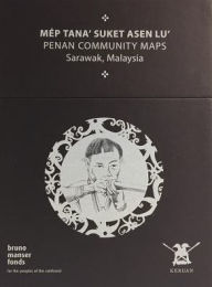
Penan Community Maps Bruno
2020-07-25 21:51:40
These 23 maps of the Penan tribal rainforest in Malaysia are the result of a fifteen-year ground-breaking community mapping project. In collaboration with Swiss cartographers of the Bruno Manser Fund, Penan tribesmen use modern mapping technology to ...
Read more
These 23 maps of the Penan tribal rainforest in Malaysia are the result of a fifteen-year ground-breaking community mapping project. In collaboration with Swiss cartographers of the Bruno Manser Fund, Penan tribesmen use modern mapping technology to trace their ancient heritage, identifying significant nomadic camps, burial sites, and blowpipe trees as well as dominant topographical features. The Penan Community Maps aim at reflecting the diversity of the Penan culture. Each map sheet consists of eight parts. While the front page displays a picture of the Penan tradition, the overview allows a simple localisation of each map sheet. All symbols and elements used on the topographic map are listed within the caption. For each map, an area-specific oral history and various pictures were selected. A drone-based aerial imagery reveals the Penan villages from the top. The villages' endorsement of the maps is given through the signature (fingerprint) of the responsible headmen. These maps are a testament to the importance of maps for indigenous rights, and the project wants to be a model for similar struggles across the globe.
Less

Compare Prices
| Store | Availability | Book Format | Condition | Price |
|---|---|---|---|---|
| Barnes & Noble | In Stock | Other Format | Other Format | Buy USD 460.0 |
Available Discount
No Discount available
Related Books
View All
Travel Like a Local - Map of Sancti Spiritus: The Most Essential Sancti Spiritus (Cuba) Travel Map for Every Adventure

Travel Like a Local - Map of Czestochowa: The Most Essential Czestochowa (Poland) Travel Map for Every Adventure
Ökologisch orientierter Tourismus auf den Kanalinseln: Stand und Perspektiven

Travel Like a Local - Map of Utrecht: The Most Essential Utrecht (Netherlands) Travel Map for Every Adventure

London Pocket Map
Travel Like a Local - Map of Tula: The Most Essential Tula (Russia) Travel Map for Every Adventure
Cornwall

Atlas of the Ethno-Political History of the Caucasus

Canadian Oxford School Atlas 10 Pack
Ökotourismus - zwei unterschiedliche Ansätze im Vergleich: Nachhaltige Regionalentwicklung mit Tourismus als Chance im peruanischen Amazonasregenwald

Régime cétogène: Plan de régime ultra-efficace et 20 recettes pour renforcer son esprit sans effort: (améliorer votre mémoire, éliminer le sucre des d
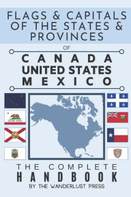
Flags and Capitals of the States and Provinces of Canada, United States, Mexico: The Complete Handbook: A color book of flags and facts of Canadian, A
A Literary and Historical Atlas of America

Settings
Reflow text when sidebars are open.